Why Rivers Bend: A Landscape Read in Curves
Why rivers bend becomes clear in their banks: follow the faster outer flow and slower inner deposits to read how a winding channel changes.
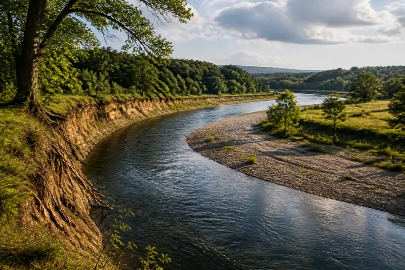
Why rivers bend is written into their banks: water tends to erode the outside of a curve and leave sediment on the inside. A winding channel is not simply taking the scenic route; its shape records the ongoing exchange between moving water, loose material, and the ground it crosses.
That exchange is gradual, but its marks are visible. Stand where a river curves around a field or wooded bank, and the outer edge may look steep and exposed while a pale, shallow shelf gathers on the inner side. These are paired signs of erosion and deposition, the two processes that help a bend grow and shift.
What makes a river start to curve?
A river does not need a dramatic obstacle to begin winding. Small differences in the channel can steer water toward one bank: a patch of tougher material, a slight change in slope, or an uneven bed. Once the flow begins to favor one side, it can strengthen the difference.
Water moving around a bend follows a curved path. The current is generally strongest near the outer bank, where it presses against the channel edge and can loosen soil, sand, or other material. On the inside, the current is often less forceful, giving some of the carried sediment a chance to settle.
The process resembles a loose thread sliding around the rim of a bowl: the motion concentrates along one edge rather than spreading evenly. The comparison is only a guide. A river is also responding to its bed, its load of sediment, and the shape of the valley around it.
Why does the outer bank wear away?
As water curves, the fastest flow commonly swings toward the outside of the bend. This stronger current can undercut the bank, especially where it is made of materials that yield readily. Roots may hold some soil in place, but a bank can still slump when its base has been worn away or its surface becomes saturated.
Look for a sharp, high outer edge, exposed roots, or fresh bare soil. These clues suggest that the channel is cutting into the bank, though a single visit cannot tell you how quickly the edge is changing. Floods can move large amounts of material; quieter flows continue the work in less obvious ways.
Bank shape depends on more than current speed. Clay, gravel, bedrock, and rooted soil respond differently to the same moving water. Where resistant rock forms the edge, a bend may remain comparatively fixed. Where loose sediment meets the flow, the channel can adjust more readily.
Why does sediment collect on the inside?
Water carries material picked up from the bed and banks. When the flow slows along the inner curve, some of that load drops out and forms a gently sloping deposit called a point bar. It may appear as a sandy or gravelly shelf, sometimes exposed when the water level falls.
The deposit makes the inside shallower, while erosion makes the outside edge recede. Together, these changes can shift the channel sideways and extend the bend. The river is not moving every part of the curve in the same direction: one bank is being removed as sediment accumulates opposite it.
A point bar can support plants as finer material gathers and the surface stabilizes. That vegetation may then trap more sediment. The result is a changing patchwork of bare deposits, young growth, and older ground—not a neat, permanent boundary between land and water.
How can you read a bend from the bank?
Start with the contrast between the two sides. The outer bank is often steeper, deeper, and more exposed; the inner bank is more likely to have a shallow shelf or a visible bar. These are tendencies, not rules. Local geology, flood history, and human alterations can change the pattern.
Imagine you are looking at a river beside a pasture, with a steep, root-fringed edge on one side and a low gravelly shelf opposite. The first clue suggests the current is cutting into the steep bank; the second suggests sediment has settled on the gentler side. If you return after a period of changing water levels, you might observe altered deposits or a freshly slumped patch, but the exact amount and timing of change cannot be inferred from the shape alone.
For a useful reading, note where each feature sits in relation to the curve, rather than treating any one sign as proof of rapid movement. Aerial images or local maps can help you compare channel positions across time, while a view from the ground shows details such as exposed roots and sediment layers. Keep away from unstable edges; a bank can give way without much warning.
What do people often ask about why rivers bend?
Do all rivers develop winding bends?
No. Some channels are relatively straight, confined by resistant rock, steep slopes, or human structures. Others divide around islands or spread through broad, shallow beds rather than forming a single winding course.
Does faster water always flow along the outside?
The outer bank commonly experiences stronger flow around a bend, but the exact current pattern varies with channel depth, bed shape, and obstructions. A visible surface current may not reveal the strongest flow beneath it.
What is a point bar?
A point bar is sediment deposited along the inside of a river bend, where water often moves more slowly. It may be made of sand, gravel, or finer material, depending on what the river carries and the conditions in that reach.
Can a river bend move over time?
Yes. Erosion on the outer bank and deposition on the inner bank can shift a bend, while floods or changes to the channel may alter it more abruptly. The amount and pace vary from place to place.
When does the curve stop changing?
A bend may keep adjusting as long as water can erode its banks and transport sediment. But not every curve grows without limit. Resistant ground, a narrow valley, vegetation, or a human barrier can constrain the channel. A flood may also cut across a narrow neck of land, leaving the former curve separated from the main flow as an isolated water body.
For readers tracing a winding river on a map, the useful question is not only where the channel bends, but what the banks reveal on either side. Why rivers bend comes down to an uneven balance: water removes material where its force meets the outside edge and lays some of it down where the current eases. That balance leaves a landscape in motion, even when the river looks still from the path.
Next time you pass a curve, look for the steep bank and the low deposit before naming the whole channel as “winding.” Those opposing edges offer a compact record of the river’s work—and a reminder that a map captures a shape that the water is still revising.