The Old Road Beneath the New Route
Old roads beneath new routes explain why modern paths still follow historic lines, and show what to look for in maps, street patterns, and terrain.
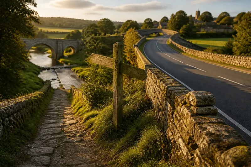
A modern road can carry traffic along a line laid down long before cars existed. An old road beneath a new route is not always a buried surface: it may be a corridor of movement that has been widened, shifted, renamed, or partly abandoned while its basic direction survives. Reading those layers helps explain why a route goes where it does—and why a nearby path may suddenly seem to lose its logic.
What does it mean for an old road to lie beneath a new route?
It means that a newer route occupies or shadows an older line of travel, even if the two are not identical in every stretch. A present-day highway may follow the broad corridor of a former turnpike, while its bends have been eased and its junctions rebuilt. A local lane may preserve a much older passage between a river crossing and a market town.
“Beneath” can describe several kinds of continuity. A road may reuse the same ground, inherit an earlier route’s purpose, or keep its general direction while moving onto firmer or safer land. The surface, name, and traffic can all change without erasing the route’s role as a connection between places.
That distinction matters. A straight modern road does not prove that its predecessor was straight, and a familiar road name does not establish an exact age. Think of a route as a ribbon that can be folded and trimmed: its shape changes, but parts of its path still connect the same points.
Why do newer routes follow older lines?
Older routes often survive because they already solve a practical problem: how to cross difficult ground and reach useful destinations. A road that links a river ford, a ridge gap, and a settlement may remain convenient even after bridges, vehicles, and land use change. Later builders often inherit that logic rather than begin with a blank map.
Terrain narrows the choices. A dry ridge can offer easier passage than a wet valley floor; a low saddle through hills can draw roads toward the same gap over generations. Rivers, marshes, steep slopes, and unstable ground can funnel movement into a few workable corridors. A route may curve around an obstacle in one era and cut through it once engineering allows.
Destinations also pull routes back into familiar alignments. Markets, bridges, ports, mills, and administrative centers attract repeated travel. If a town remains an important stop, roads serving it may keep a shared approach even as their wider networks change. The reason for the journey may differ; the useful connection remains.
How can you spot an older route in a modern landscape?
Look for small mismatches between a road’s current job and its shape. A broad street that narrows abruptly, a lane that bends around a boundary, or a footpath continuing beyond a modern junction may preserve a previous alignment. None is proof on its own. The clue becomes more persuasive when several features point in the same direction.
- Look for abrupt changes. A wide road may narrow where newer construction stops and an older lane begins.
- Notice awkward bends. A curve that seems unnecessary for present traffic may reflect a former property edge, slope, or approach to a crossing.
- Check where paths meet. Several minor tracks converging at a bridge, ridge gap, or old town entrance can suggest a long-used junction.
- Compare street endings. A lane that stops at a new road may once have continued in line with another path on the far side.
- Watch for shifts in level. A sunken lane or raised bank can mark a route shaped by repeated passage or later earthworks.
Use a current map alongside older maps and aerial imagery where available. Compare junctions, crossings, and settlement entrances, not just the road’s overall direction. A map may record a named turnpike or an old bridge approach, while imagery can show a surviving track across fields. Look for corroborating details before treating a tempting alignment as established history.
Why are old routes redirected instead of simply erased?
Redirection lets a route keep serving its destinations while avoiding a new obstacle or meeting a new need. A bridge may replace a ford, shifting the approach to a riverbank. A town may grow around a road, then divert through-traffic to a bypass while leaving the old street in use for local trips.
Sometimes the change is gradual. A route that once crossed open land may be edged by buildings, with a straighter road built alongside it. The older line can survive as a service lane, walking path, or quiet street. In other places, a new embankment or railway cuts across the former corridor, leaving short disconnected fragments.
Say an invented village has an old lane that reaches a river at a shallow crossing. A later bridge is built upstream where the banks are firmer, and the main road bends toward it. The expected visible result is a modern approach to the bridge alongside a fading track toward the former ford; the two lines reveal a changed crossing rather than a wholly new connection.
What can maps and names tell you about route changes?
Maps help distinguish a route’s broad continuity from the exact position of its surface. Compare the shape of junctions and the relation between roads and landmarks across editions. A road that seems to vanish may have become a footpath, private drive, or field edge. A line that appears unchanged may have been widened or shifted within its corridor.
Names can offer another clue, but they need careful reading. Terms such as “Old Road,” “Turnpike,” or “Causeway” may preserve a local memory or describe a later feature; the wording alone cannot date the route. Place names may also move when a road does, so a name attached to one stretch today might once have referred to a wider corridor.
Where the answer depends on a map’s date, a road record, or a locally maintained name, check the relevant map notes or local records rather than assume every label describes the same period. Keep observations separate from conclusions: “the paths align” is visible; “this is the former road” needs supporting evidence.
Which questions help explain an old route?
Can a modern road follow an old route without using the same ground?
Yes. It may keep the older corridor’s direction while shifting to a nearby bridge, gentler slope, or safer surface. Continuity can describe the connection and purpose, not an exact match of every bend.
Does an “Old Road” sign prove a route is ancient?
No. The name may distinguish a local street from a newer road, or preserve a community label without specifying its age. Compare maps and physical features before assigning a date.
Why do old paths sometimes stop at a modern road?
A new road, railway, fence, or development may have cut across the earlier line. The path can survive as disconnected pieces, and their alignment may help show how they once joined.
What is the best first clue to follow?
Start with a crossing or a narrow passage through difficult terrain, then trace the routes approaching it from both sides. A shared destination or natural bottleneck often explains an alignment more clearly than a road name does.
An old road beneath a new route is easiest to understand as a set of choices repeated and revised: where to cross, which ground to avoid, and which places to connect. On your next map comparison, follow one junction outward in both directions and ask what obstacle or destination it answers. That small question can turn an ordinary bend into a readable trace of movement.