Village Green or Main Street? Two Ways a Settlement Gathers
Village green or main street: learn to read a settlement’s shared center or linear spine, and plan a week of observation that reveals how each works.
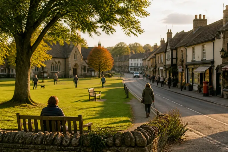
A village green or main street tells you where a settlement gathers, but the evidence is not always where a map suggests. A green may look like empty space, while a street may seem only a line between buildings; watch how people use each over a week and both become readable civic forms.
The distinction is not simply open versus built. A green organizes buildings around a shared center; a main street strings them along a common route. One makes a place feel gathered, the other makes it feel connected. Many settlements combine the two, and the useful question is which pattern does more of the organizing.
What does each pattern put at the center?
A green is an open area whose edges help define the settlement. Homes, a meeting hall, a church, a shop, or a pub may face it, even if they are not evenly spaced. The open ground becomes a common reference point: a person can say “by the green” and be understood without naming a particular storefront.
A main street makes a different promise. Shops, houses, civic buildings, and side lanes line up along a route. The center is less a single place than a stretch of public frontage, where movement and exchange overlap. A post office near one end and a bus stop near the other may both feel central to different residents.
Think of the green as a shared table and the street as a hallway with doors opening onto it. The analogy is imperfect, but it helps: one gathers people around a common space, while the other brings them past a sequence of destinations.
How can a week of observation reveal the pattern?
Use a week as a simple field routine, not as a survey of everyone’s habits. Keep a pocket notebook and a printed street map or a map app. Mark the green, the main street, connecting lanes, public buildings, benches, bus stops, and places where the public route changes character. Observe from public places and avoid recording identifiable details about individuals.
- Monday, map the form. Note where building fronts face and where entrances open. Draw the green’s edges or trace the street’s continuous frontage, including gaps and side roads.
- Tuesday, follow the approach. Walk in from more than one direction. Record whether routes lead toward an open center, run along a spine, or do both.
- Wednesday, look for pauses. Notice benches, sheltered corners, shop thresholds, and places where people can stop without blocking movement. Mark these as potential gathering points, not proof of how they are used.
- Thursday, observe a quiet period. Look for the pattern when shops are closed or foot traffic is sparse. Does the open center still make the settlement legible? Does the street still connect recognizable destinations?
- Friday, revisit at a busier time. Watch how movement shares space with conversation, deliveries, or waiting. Keep the focus on the arrangement, not on judging particular people or activities.
- Saturday, check the edges. See how homes and public buildings meet the shared space. A fence, parking area, broad verge, or blank wall can change how close a place feels, even when the map shows a short distance.
- Sunday, compare your notes. Mark the strongest gathering point and the strongest route. If they differ, describe the settlement as a combination rather than forcing it into one category.
At each visit, write down one concrete observation and one question. “The hall faces the green” is an observation. “Does the hall draw people here, or does the open space make the hall easier to find?” is a question worth carrying forward.
What should you notice at the edges?
Edges reveal whether public space feels shared or merely visible. Around a green, look at gates, low walls, paths, tree lines, and the direction of entrances. A clear path from the street onto the open ground suggests a different relationship from a space ringed by fences or separated by a road.
Along a main street, look for doors and windows facing the route, as well as long blank fronts, parking lots, or service entrances. Continuous doors can make the street feel like a sequence of public-facing places. A wide verge or building set well back may soften that connection, while a busy junction can interrupt it.
Do not treat neat geometry as a verdict. A green need not be a perfect square, and a street need not run straight to organize a settlement linearly. The practical test is whether buildings and everyday destinations orient themselves toward an open center, a route, or both.
How do the patterns shape movement and meeting?
A green can offer room for several activities without making them share a narrow path. It may make a meeting hall, a notice board, or a public event easy to locate. But an open lawn alone does not show that people can reach it comfortably, or that it serves as a gathering place throughout the year.
A main street can place shops and services along a route people already travel. That can make small errands and chance encounters part of the same walk. Yet a street’s public life may be concentrated near a cluster of shops or a bus stop, rather than spread evenly from end to end.
Imagine a settlement where the hall faces a grassy square, but the grocery store stands on the road beyond it. Over the week, you notice that people approach the hall by paths across the square, while errands follow the road. The useful reading is not “green or street,” but “green for gathering, street for everyday connection.” That distinction describes what the layout invites without claiming to know every resident’s experience.
What questions help distinguish a green from a street?
Can a green still organize a settlement if it is not in the middle?
Yes. Its position on a map matters less than whether nearby buildings and paths orient toward it. A green at one edge can remain a recognizable shared center for the cluster around it.
Can a main street be a gathering place as well as a route?
Yes. A shopfront, market area, bus stop, or widened pavement can create places to pause along the route. The linear pattern remains, but public life gathers at particular points on it.
What if a settlement has both a green and a main street?
Describe how each contributes instead of choosing a single label. One may organize public meetings while the other links homes, services, and arrivals.
Does a map show which place people actually use?
A map shows arrangement and access, not the full rhythm of use. Pair it with observations at different times, and treat what you see as a partial view rather than a claim about everyone.
How should you describe a mixed settlement?
Use specific language tied to visible features. “Buildings face a common green, with shops lining the road beyond it” says more than calling a place picturesque or compact. If the street has a concentrated cluster, name that too: “The main street gathers around the shop and bus stop, while the green serves the hall.”
When the pattern is unclear, check the settlement at a different time or approach it from another direction. A row of buildings may seem to define the center from one entrance and appear secondary from another. A short revisit can resolve that impression without turning a simple reading into a grand theory.
For a village green or main street, the most revealing note is often the relationship between the two: where people can pause, what fronts the shared space, and which route carries them onward. That wording lets the place retain its particular character instead of squeezing it into a tidy label.