A Walk Along the Boundary Between Field and Common
A walk along the boundary between field and common helps you read gates, paths, signs, and shared ground without assuming what a border means.
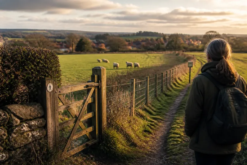
A walk along the boundary between field and common can reveal how a landscape is used without telling you, by itself, who may enter. A worn path, a clipped hedge, and a wooden gate each offer clues; none is a complete explanation. Walk slowly, stay on routes open to you, and treat uncertainty as part of what the landscape is saying.
This is not a hunt for a hidden line. It is a way to notice how people, animals, and maintenance shape the edge between individually managed ground and land used in common. In eastern landscapes, that edge may run beside a pasture, skirt a village, or meet a lane. Use these six observations as prompts, not as a substitute for local access information.
1. Where does the edge first become visible?
Begin where a change in use catches your eye. Cropped rows may meet rough grass; a close-mown strip may give way to scrub; a broad field may narrow beside a footpath. Note the change without assuming it marks a property boundary. A shift in vegetation can reflect soil, drainage, shade, or routine care as readily as ownership.
Look for more than one clue. A hedge might divide fields, shelter livestock, or screen a track. A ditch may carry water rather than define a boundary. Ask what the feature seems to do, then leave open who maintains it and under what arrangement.
If the edge is difficult to identify, that is useful information. Shared use is not always marked by a crisp fence, and managed land is not always visibly enclosed. Think of the boundary like the seam on a coat: it shows where two pieces meet, but not why they were joined or who is entitled to wear it.
2. What do gates and stiles invite you to do?
At a gate, pause before touching the latch. Read any sign, notice whether a marked route continues beyond it, and look for a stile or gap that appears intended for walkers. A gate can control livestock while still serving a public path; it can also close access where no path is open. Its shape alone cannot settle the question.
Signs may distinguish a public footpath from a private track, identify a field operation, or ask visitors to keep dogs close. Follow clear local directions and do not enter enclosed land simply because a gate is open. If access is unclear, use a map or ask the relevant local access authority rather than testing the boundary.
Pay attention to the small acts of care a route requires. A latch left usable, a stile kept clear, or a waymark visible from the path can suggest ongoing attention, but does not prove who is responsible. Notice the provision; avoid turning it into a claim about rights.
3. Who appears to use the ground, and how?
Look for signs of use at a respectful distance. Hoof prints, cropped vegetation, grazing animals, cut hay, or a line of walkers can show that different activities share space or take turns. These traces change with season and weather. One quiet visit may miss a use that is regular at another time.
Separate observation from inference. You might see a flock grazing and infer that the field is used for livestock; you cannot tell from that alone who owns the animals, who holds grazing rights, or whether the arrangement is temporary. Similarly, a broad grassy area beside homes may look open, yet its access rules may be specific.
Imagine you reach a pasture where a public footpath is marked, sheep are grazing, and a notice asks walkers to keep dogs on a lead. You can follow the signed path and comply with the notice, while recognizing that these details reveal only the route and current request—not the full history of the land or its management.
4. What does maintenance tell you?
Notice the difference between a boundary that is actively tended and one that is allowed to grow. A trimmed hedge, repaired fence, cleared drain, or mown verge records labor. It may be carried out by a landholder, a tenant, a local group, or a public body. The work is visible; the arrangement behind it may not be.
Maintenance can also show competing needs. A clear path helps walkers pass, while a closed gate may keep animals from reaching a road. A hedge left thick can shelter birds and separate livestock; a cut section may make room for a farm vehicle. Rather than judging one treatment as neglect or improvement, ask what practical purpose it could serve and what evidence supports that reading.
Keep your attention on what you can see: fresh cuttings, a repaired post, a blocked drain, or a path narrowed by brambles. If you notice a concern affecting a public route, record its location and report it through the appropriate local channel instead of moving barriers or altering the land yourself.
5. How does the boundary connect to the settlement?
Follow the edge’s relationship to nearby homes and lanes. A path may link a village street to fields; a common may sit beside houses and offer a place for walking or grazing; a narrow access lane may serve farm traffic as well as residents. These connections help explain how shared ground fits into daily movement without making every nearby route public.
Listen and look for changes in activity. The sound of machinery, the passage of a tractor, or a worn entrance can indicate a working landscape, while benches or a noticeboard may suggest public use. None tells the whole story. The useful question is how the boundary organizes movement: where people pass, where vehicles turn, and where animals are kept apart from them.
At junctions, resist shortcuts across fields. Stay on mapped or clearly signed paths, especially where a route meets a working entrance. A small detour can preserve the distinction between a route open to walkers and ground that is not.
6. What should you leave unresolved?
Some questions cannot be answered from a walk. A boundary may reflect an old agreement, a current tenancy, a public right of way, or a mix of arrangements. Fences and signs can change, and local rules vary. Where the answer affects access or responsibility, check current local maps and official guidance; follow signs and land-manager instructions where they apply.
Keep a simple field note if you want to remember what you saw. Record the route, the visible feature, and what remains uncertain: “hedge beside marked footpath; gate has livestock notice; ownership not established.” This wording keeps observation separate from assumption and makes it easier to ask a precise question later.
A walk along the boundary between field and common is most useful when it leaves room for more than one explanation. Notice the path, the work, and the people or animals using the ground; then respect the limits of what those signs can tell you. That careful attention turns an ordinary edge into a clearer picture of how shared resources connect a landscape to the lives around it.